Translate

Thursday, May 22, 2014

Mt. Hood and Columbia River Gorge

From Fort Stevens, it was a nice ride through Astoria and then east of Portland to Troutdale on Route 30.

A local at our campground recommended the Mt. Hood Scenic Loop and we were glad we tried it.

A very scenic ride on Route 26 to Route 35 and back to Interstate 84.  It began immediately with fresh picked strawberries right at the strawberry patch.  The many views of Mt. Hood started quickly.


Some beautiful views of Mt. Hood along the way. This was right before the Mt. Hood parking lot along the 6 mile road up to Timberline Lodge.


Lady Blue was quite comfortable with the climb.


The parking lot is busy.  Most of these cars belong to snowboarders and skiers enjoying a run down the mountain. Timberline Lodge is a short walk to the left ahead and the lifts are right there.


The interior is welcoming and warm with lots of fireplaces. 


This is the original lodge built under the WPA in the 1930's.  With so many lumber workers and others out of work in the depression, there was no problem finding workers to build this in 15 months.

If the above was looking familiar to you, you might have seen it in a few exterior shots from The Shining with Jack Nicholson in 1980.


This is a display showing a room set up in the 1930's.

Look comfortable?


Even more comfortable when you see that welcoming fireplace and the typing desk with the old typewriter.

I shouldn't say "old", because it looks exactly like the typewriter I used for homework during the high school years.


Yes, Lady Blue is parked outside at 6,000 foot elevation. 

Jan and I are quite impressed that Marsha and Mark climbed to that 11,245 foot summit a few years ago.

Can't believe that Dave is going to do it at the end of next month!!


The original lodge has comfortable spots like this lounge with a fire in the fireplace.  I believe that is a glass of white wine being enjoyed-----hmmmmm?


At the original building is a very nice full service restaurant and an even nicer bar/lounge with great views out to the mountain or over to Mt. Jefferson, also snow covered.


Not to be missed , if you do the Mt. Hood scenic loop, is this view from the quiet Trillium Lake .  It is almost right across from the Mt. Hood road on route 26.  Sometimes, you will have a mirror image of Mt. Hood.


Another great view is from Panorama Point, right off Route 35 in Hood River.  It was a little hazy this day, but still a good look at Mt. Hood.

Also had a good view of Mt. Adams in Washington state.


Jan and I had doubts about going all the way back to Troutdale after the Mt. Hood loop. 

But , we thought it was a good decision when we started the next day on a scenic tour down the Columbia Gorge on old Route 30.

Route 30 was the first scenic highway in the US built under the direction of Samuel Lancaster,engineer, in 1913.


The idea was to "not mar what God had put there" and to showcase waterfalls and other "beauty spots" along the Gorge.


This is the Vista house, set at a high point along the Columbia River as a rest stop.

If you stop by, take the time to look upstairs and downstairs at this beautiful building. Oregon State Parks took over this building and renovated it.


 This is just the view west towards Portland. 

As a road built in the early 1900's, you soon realize that it was not meant for modern, larger vehicles.  While a limit of 40 feet is indicated, one lane bridges, tight S curves, and corners like this one might prove difficult in larger RVs.  Especially with traffic.

Lady Blue was very cautious!!


Along this scenic route is supposedly the greatest number of waterfalls in the US.  We did not stop at all of them. Some of the falls had very small parking lots and there were a number of tourists. But, it was also on a weekday, so we found some nice stops like Bridal Veil Falls.


The most popular and largest falls are Multnomah Falls.  There is a large parking lot on Route 30 and an even larger lot on Route 84.


I believe this is the fourth largest falls in the US.


There are other stops along the Columbia Gorge, but one that is definitely recommended is the Bonneville Lock and Dam.

Another WPA project during the depression, the desperate work force flocked to this project, no questions asked.  While some members of Congress questioned the need for such a large hydro-electric project in the northwest, they were soon silenced when the electricity became all important for producing planes and one Liberty ship per day from plants in the northwest during WWII.

The flow over the spillways is impressive and loud.

The area is large with three producing turbines, locks for moving large and small boats and barges, and a great fish step.


The first floor has a number of see-through panels to watch the fish swim upstream past the dam.

I don't know what type of fish this is, but we saw many like this as well as a few larger salmon.


We believe this was a Lamprey eel.  He was just sticking around on the glass.


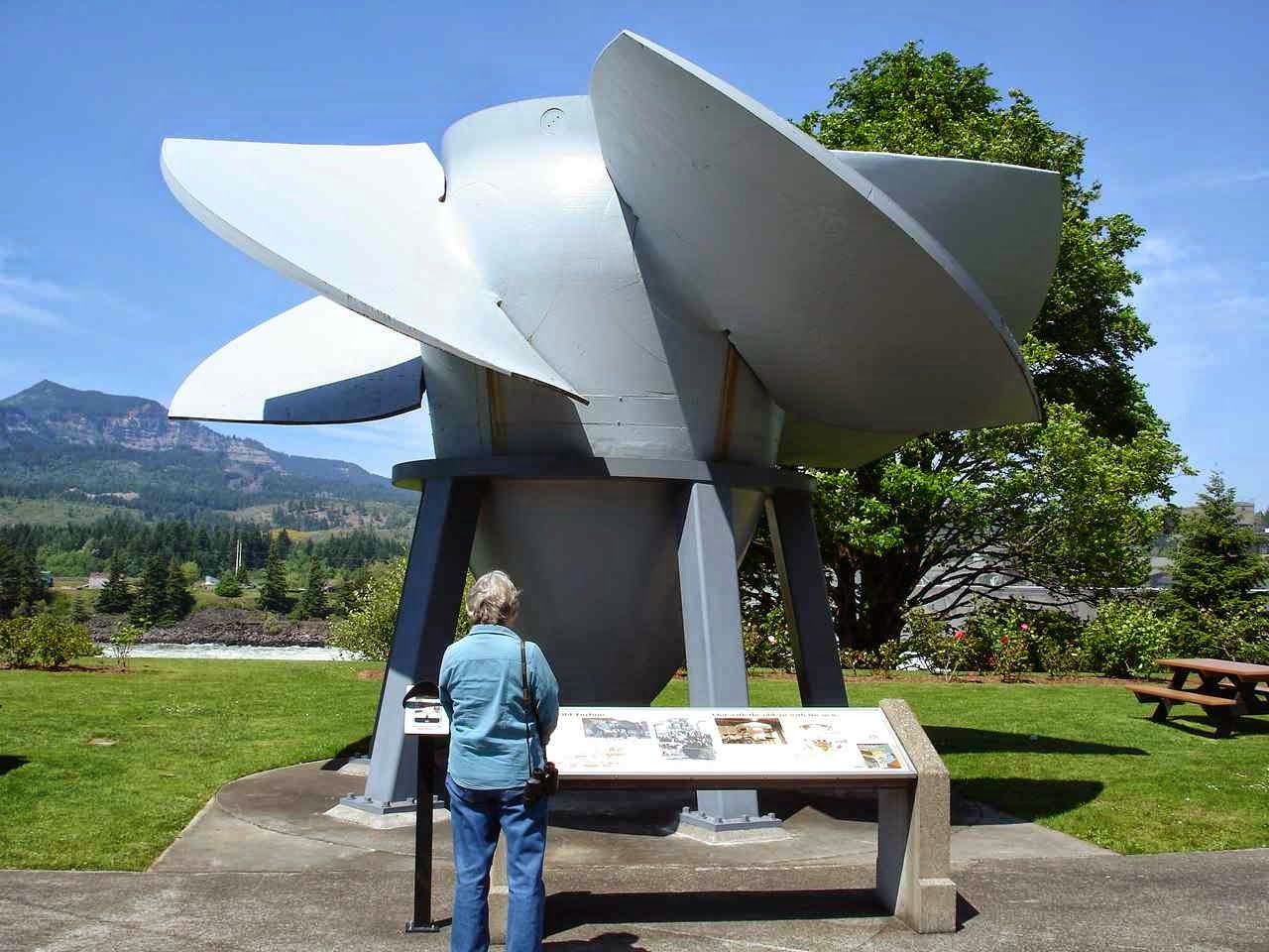
Jan is standing in front of the old turbine from one of the sections that had been replaced with a newer model years ago.


The Columbia River was great for this project because of the volume of water and the force to spin these large turbines.


We are now here at Memaloose State Park in Mosier, Oregon , right on the Columbia River. A great little spot with water only for $19 per night.


All kinds of river traffic in front of our site.


Not to mention, barges and trains on the Washington side and also right below us where you see the power lines for the track equipment.

I've counted up to 100 plus cars on many of the trains and there are usually at least one or two per hour on each side.


Not a bad spot for a sunset either.

However, Memorial Day weekend starts tomorrow and this park will be full.  With no reservations, we will take our chances across the river.

It's an adventure!!


Sunday, May 18, 2014

North Coast of Oregon

Starting from Newport, Oregon, this is Yaquina Head Lighthouse just across from South Beach State Park(see last posting).  This is a well kept lighthouse, including a visitors center and a docent for tours.  All of this is free on your America the Beautiful pass.


Back in the late 1800's, this was maintained and kept very similar to New England lighthouses.  There were additional buildings , homes and animal pens, as well as gardens.

The lighthouse is one mile into the ocean.  Now accessible by road, back then it was trails and beach and boat.


There is something I can't resist about pictures looking up a spiral staircase.


Or down.

Smile, Jan.

This lighthouse is maintained by the Bureau of Land Management (BLM) .  They had some interesting maps and information at the visitors center on BLM lands, including the national forests.


At the top of the stairs was the huge Fresnel lens.  Using those things you learned in Junior High Science classes ,like light refraction, the light is focused into one powerful , thin beam.  The lighthouse is still active, though it is now fully automated and does not require the continuous filling of oil for burning. The following website offers more info. The website comes up on the original Yaquina Bay Lighthouse. You  want to look at Yaquina Head Lighthouse.
http://www.yaquinalights.org/yaquinabay.html

On the rocks below the lighthouse are many Harbor Seals.  Other rocks are home to thousands of shore birds.


Route 101 is a scenic road for most of its travel right along the Oregon coast. Some 363 miles of beautiful coast.

There are small , quaint fishing villages as well as the occasional vegetable stand. 

This stand had wonderful artichokes-not in season--, some very tasty and tender asparagus, and great lemon blueberry scones from their own bakery.


Also along the way are larger towns, such as Tillamook.

This is from the Tillamook Air Museum which is right along Route 101.


This is a WWII BMW motorcycle with sidecar.


To the right is an original 1944 Willys Jeep.

The tall post attached to  the front bumper was to snag and cut wires that would be strung across the back roads intending to decapitate unwary chasers.


The famous F-14 Tomcat jet, retired from service in 2006.

Some might remember Tom Cruise in Top Gun, who flew an F-14A Tomcat off the USS Enterprise.


We could have stayed for free as Harvest Hosts members at the Air Museum. But, we went across town to Blue Heron French Cheese Company.

This is also a member of Harvest Hosts and Lady Blue was quite happy to have plenty of room around the antique trucks and chickens.


I had to look closer at this antique.  It came all the way from Buffalo, New York. 

At 13 horsepower, it was run by steam power.  The operator could feed wood into the back, steam would be released from the stack, and a horizontal piston would drive the rear wheels.


We had to add this picture for Cliff and Vicki.  The old milk cans topped with old tractor seats seems like a great antique addition to the yard.


Anyone from the west coast knows the company Tillamook Cheese.  We saw their butter and cheese from California north, but also in some stores further east.

I love the story of the farmers in the 1800's realizing that the land was too wet for regular crops.  Turning to dairy farming, they also found out that milk did not travel well over the ocean and long land routes.
So, cheese became their trademark.
They also realized quickly that the hundreds of local farmers would do much better to form a cooperative to make and sell their own cheese across the country.
Thus, the Tillamook County Creamery Assc.


There is a nice factory tour inside.  Even parking outside, you see a number of milk tanker trucks arriving with fresh milk.  Inside you can watch a number of videos showing families running very clean, modern dairy farms. I was surprised to read that milking was done twice a day, one of which times was 2:00am.  Bur with hundreds of cows on each farm , the milking process takes 4 hours each time.


Note the figures to the left. 

1.7 million pounds of milk every day.

Also, 10 pounds of milk to make each pound of cheese.


As a side note, Jan and I found the Tillamook Old Fashioned Vanilla Ice Cream to be among the best ever.


Still much to see along the coast.  Along Cannon Beach, you can look for the Haystack(right) and Needles(yes, the smaller rocks).

Miles and miles of accessible beach to walk or just sit and enjoy.


Also. on the way, is Seaside.  Seaside has a long, flat beach that is great for swimming and surfing.  There is a boardwalk(now made of cement) that goes for about 2miles right along the beachfront.

This statue is of Lewis and Clark.  We are very close to their 1805 winter quarters on the Columbia River. This spot was used to boil down ocean water for salt needed for the return home of the Corps of Discovery.

Jan and I enjoyed great steamed clams at the restaurant in the background on the left.

Which brings us to Fort Stevens State Park at the mouth of the Columbia River.

This is the largest state park west of the Mississippi River.  Many sites and quite full for the entire weekend.


The park has miles and miles of trails for walking, biking, or horseback riding.

By the way, this is that blossoming bush that we mentioned back a few issues.  It is Scottish Broom and evidently is an invasive species.  Down the coast, they were organizing groups to tear out any bushes they could see during the blossom season.

Oh well. It looks great here.
The bike trail(10 plus miles)brought us to the South Jetty.  At this point we are looking at the Pacific Ocean.  To the right the jetty goes out into the ocean and further to the right is the mouth of the Columbia River. You can certainly understand why this area could be so dangerous for ships.


Further along the bicycle trail is the Columbia River.

You can stand or sit here and watch all kinds of boats go by.  Small and large fishing boats like these, or large shipping containers and cruise ships.

We are looking across the river to the Washington coast.


The next day is another bike ride. This time to the Fort Stevens museum.  It took a while for the US Congress to realize that this area ,explored by Lewis and Clark in 1803 and ceded by Great Britain in 1846 , had no defense and could be seized by a small band or army.

So Fort Stevens was built. Jan and I were fascinated to know that Major General Stevens for whom the fort was named, was a native of Andover, Mass. To imagine travel and life in the early 1800's.  A young military man travels to the west and eventually becomes the Territorial Governor of Washington Territory.
It inspires you to read more about travel along the Oregon Trail and the good stories of the Lewis and Clark expedition.

The park museum concentrates on the WWII bunkers and setup for the fort.  The picture to the right depicts the Japanese sub in 1942 that was responsible for the only missiles fired at a US military base since 1812.  That plane has pontoons, but you know it was a hazardous launch to get off that sub in rolling seas.  There was no damage from the sub firings.  What was also interesting in the museum were the original newspapers from the war reporting on many things, including the large number of balloon bombs that were flown from Japan to the west coast. Many fell harmlessly, but some were picked up by unknowing families and children to disastrous consequences.

Saturday was threatening rain, so we gave Lady Blue a workout to visit the Lewis And Clark National site.  Fort Clatsup was their winter quarters for 1805.  A few short months, but much needed to prepare for their return trip. The fort was named for the Indian tribe that was friendly to the group.


President Jefferson was hugely interested in expanding to the west and finding a river route to the Pacific. 

It was interesting to read about Lewis studying for mapping skills and journal skills to prepare for the trip.


Of the 33 or so members of the Corps of Discovery, all made it safely back home except one who died of possible appendicitis early in the trip.

Mostly they ate well, thanks to the hunters with the group and the friendly Indian tribes they encountered along the way.  Not too sure about the "dog" on the menu.


 The Clatsup Indians were very good traders and well equipped for the coastal life.  Their best loved tree was the Cedar.  It was used for canoes, baskets, rope, mats, hats, building, and these boxes.

The boxes would be filled with water to which hot stones would be added.  Then they would use the hot water to cook.


Using the original plans, a replica Fort Clatsup was built at the museum. 


A small , but very efficient military style fort.


Yes, that is a fireplace chimney made of wood.


The inside fireplace for the enlisted men was quite unusual by our standards.  It is an open fire and note that the chimney above is made of wood.


The Captains Lewis and Clark had nicer fireplaces with a mantle.


This picture may be hard to see, but Jan and I loved this door.

It is a solid, heavy wooden door with a substantial catch that would fit securely in a latch.

What I really liked were the hinges.  Note that they are also made of wood and dowels.  Very substantial.


Jan sits comfortably on this bench at Clatsup made from one piece of wood. 

We are thinking it would be so easy to just cross the bridge to Washington.  But, there is so much to see along the Columbia River Gorge, that we think we will head east and enjoy the scenery.

By the way, at 46.16 latitude, we are now north of Livermore Falls, Maine (44.4)  In case you were wondering, Somerset, Mass. is 41.7.