
From Kendall COE we head north on route 127 to the Luis B Nunn Parkway. A lot of parkways in Kentucky, many are 4 lane divided highways. Jan and I are aiming for the Barren River Lake State Resort Park. We like to try different state parks ,but this ranks at the bottom of our list. Plenty of sites to choose from but very few are level. Also you better be careful how you back into your site. If you are too close to either side you could have a 10 foot drop when you step out of your unit. So---Jan and I remembered a Corps of Engineer Park we had stayed at a few years ago called Tailwater. It is on Barren River Lake below the dam. When we look for dates, it indicates it is open from September 18 to April 14 , but there are no services(bathrooms, water, electricity) It is free camping. The sites are beautiful along the river. A number of fishermen come in here , as well as hunters. Just remember there are no facilities. We are the only campers along with a host. The host was quite pleasant , also indicated that the deer hunters have been quite successful here. He had put up as many as 10 deer in freezers for the past winter. The next day we head west up Route 231 to Route 68 west. A delicious bakery in Auburn, The Country Side Bake Shop, we like to stop at. Home made breads, great sandwiches, and the best banana nut bread and cinnamon buns to remind us of Grammies. Auburn Bake Shop
 |
From Auburn, it is still west on Route 68 and 80 to Interstate 24 north. At the top of Land Between the Lake we try a suggestion from our Passport America app. These are half price campgrounds on certain days or certain times of the year. We pay $15.90 for a comfortable stay and continue on the next day. South on Purchase Parkway to Union City and Reelfoot Lake State Park in Tiptonville, Tennessee. Nice views of the water and Bald Cypress trees. For this weekend there are a number of duck hunters that head out in their boats.
|

When you get into some of the remote areas of Tennessee and other states, you are following local state roads through farm country and often through the farms themselves. We follow 78 and other local roads south to Interstate 155 west. Along the way are many cotton fields. Some have been harvested and rolled into these enormous yellow bales.

Some fields are still waiting to be harvested. Looks like they are covered in snow or covered with popcorn.

Route 155 takes us across the Mississippi River into Missouri on an older bridge.

In Missouri, we head south on Interstate 55 to one of our favorite parks, Tom Sawyer , in West Memphis, Arkansas.
Can you imagine the first time we saw this sign with our 5th wheel? What do you mean, No Trucks and Dead End?
Plus this road takes you over a levee which also seems a little suspect.
Can you imagine the first time we saw this sign with our 5th wheel? What do you mean, No Trucks and Dead End?
Plus this road takes you over a levee which also seems a little suspect.

But, even on a cold, rainy day, our site on the riverbank gives us a great view of the barges. This barge pack is made up of six barges long by three barges across for a total of 18 barges.

A little brighter weather and the view out our window.
This video will give you an idea of the barge passing us and how hard the tugboats have to work to push them upstream. We took that video from right behind Lady Blue. Sometimes we have been here when the river is down 20 feet or so and the barge traffic is limited. Another time we were here and had to leave because the campground was due to flood when the river flooded the next day. This time the river is high, but not near to flooding.

They have been working in the park. Besides a number of new sites by the river, there is this new tree platform for your viewing pleasure.

The weather in Arkansas was quite cold and the forecast was calling for nights in the 20's and some snow. So we drive a number of miles to one of our favorite campgrounds in Russellville, Old Post COE Campground. Getting there, we try a new route up 55 and west on route 64. Following Route 64 to Route 40. A much quieter route. The route was suggested by a wonderful, friendly staff person at the Arkansas Welcome Station on Route 55.

A nice historical display at the visitors center by the dam. Those are bales of cotton about the size used to pack on the old stern paddle wheel steamers on the Arkansas River. Leave it alone Bruce! That's not what they mean by picking cotton.

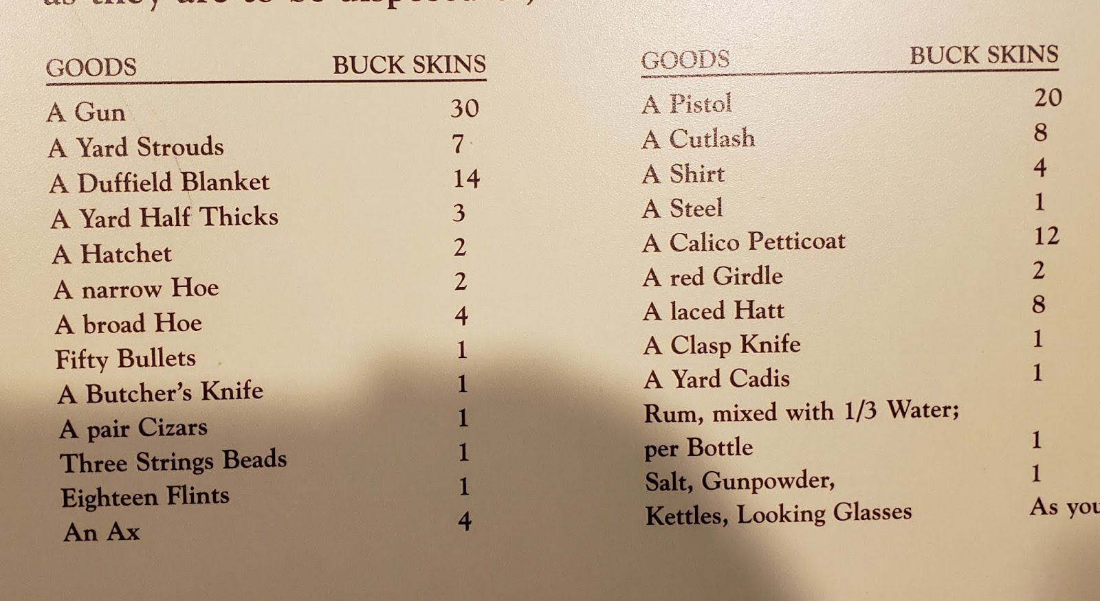
This info display is a little hard to read, but the left icon indicates a barge tow of 15 barges (3 x5), which would carry as much as a 2 and a quarter 100 car trains. Or as much as 870 large semi trucks.
The savings on fuel and lower pollution are huge.
The savings on fuel and lower pollution are huge.

Some of the cargo on the barges here on the Arkansas River.

Our neighbor indicated that there were as many as 15 eagles sighted here at the park this year. This is a favorite nesting spot with lots of available fish by the dam. We took this picture behind Lady Blue with the help of our telephoto lens and a little cropping.

Our site at Old Post. The Arkansas River is right behind us.

We had to print out some tax papers, so we found a nice staff very helpful at the Pope County Library in Russellville. We enjoyed the name being the same as Jan's maiden name. Printing was easy.

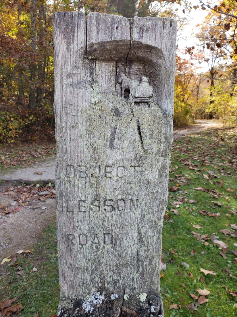
The same camper that mentioned the eagles at Old Post also mentioned he was going on an eagle viewing by boat at the state park in Russellville. Sounded great. We read online that Lake Fort Smith State Park in Mountainburg ,had been renovated recently, so we head there to check it out.

The park was closed for a few years while they enlarged the dam to provide more water for locals. In the process the old park went under water and a new one was created. This was opened in 2008. Beautiful!! Above is a display for an early settler log cabin with hand hewn logs and local mud for sealing between.

We loved the description of this covered wagon as the "pickup truck" of the early settlers. It carried everything they needed to get started with a homestead. No heading down to the Lowe's for supplies though.

Yes, we still are seeing a number of bear warnings at campgrounds.

Just a small list of chores around the homestead.

A few of the items needed by every settler.

This reminded us of our early days in the late 1940's and early 1950's. Grandmother Marshall was constantly mending old clothes, socks, and sewing new clothes from dress patterns and more. Sound familiar?

Things we don't think about. Storage containers, lamps, saws, and items needed for the work animals.

This is one item that has made a comeback. There are many groups across the country that are promoting spinning wheels and raising sheep or Alpacas for wool.
We took this video near sunset. The new park is well designed . Our only complaint is that there are only 30 sites. We could only stay one night because the campground was full for the weekend.

Even the Day Use Area looks welcoming. The lake access is to your left.

From Fort Smith, we head south on Route 71 and 40 to 71 south again towards Gillham. Part of this route takes us right up to the Oklahoma border. Around Fort Smith we cross the Arkansas River.
There are many lakes and Corps parks coming south out of the Ouachita Mountains in Southwest Arkansas. One recommended to us by the gentleman at Old Post was Cossatot Reefs COE on the Cossatot River before Gillham Lake.

We used to have a number of praying mantis at our old house. Actually, not so many in the last years. Not sure why. So that was what first came to mind when Jan saw this walking stick on our camp road at Cossatot. Can you imagine how hard they are to find on the forest floor? We barely caught this one because it was contrasted against the pavement. The colors exactly match the twigs on the local pine trees with the right color green for pine needles at the ends.
You have to play this video all the way to the end to catch the heroic camera man with " I'm outta here" .
Come on Bruce, it's a little insect.
Come on Bruce, it's a little insect.

Big Pines Lodge Website

Coming into Texas, we found our favorite COE at Wright Patman in Texarkana was closed for improvements. But we found a new favorite in Clear Springs COE. After that stop, we head south towards Marshall, Texas and an overnight that allows us time to shop for Thanksgiving. A small park close to Caddo Lake State Park on the river.

On weekends and summer time, there are boat rides and a great Louisiana style restaurant on the water.

Just in time to Rayburn COE park for Thanksgiving sunset from our site.
A little video gives you our backyard and a very small part of the reservoir. The far shoreline is 3 miles away.
A little video gives you our backyard and a very small part of the reservoir. The far shoreline is 3 miles away.

And ending this with an unusual view of the clouds being split into a small rainbow by the sun over the lake.


