Translate

Tuesday, April 30, 2019

Villaneuva State Park, Storrie Lake State Park, Angel Fire RV Resort, Sugarite Canyon State Park,New Mexico; Trinidad Lake State Park, Colorado

From Cochiti Lake , we head back to Route 25 north. 
The picture above is coming into Santa Fe, New Mexico.
We made a short stop at Santa Fe RV Repair. Bruce had zapped our air conditioner control with a strong jolt of static electricity. It seemed like a blown fuse, but he couldn't find it. A quick consult at Santa Fe and fuse found(was not labeled well).

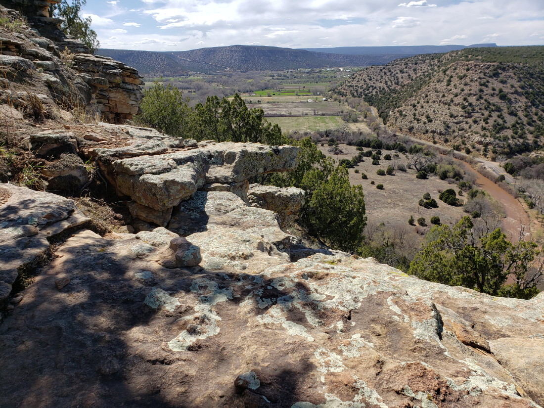
Still on Route 25, past Santa Fe, we exit Route 484 and 3 to Villanueva State Park. This is the land of red clay.

There are many examples of old homes built with red clay bricks. For hundreds of years and more, native inhabitants were making the bricks from clay, soil, hay and sun drying. The bricks become as solid as rock.

The road follows the Pecos River to the park.
This is one of New Mexico's nicest , if small , parks.

A great dry camping spot right on the river.
The Pecos can be seen running just beyond the last rock. The color is brown from soft dirt river bed and banks.
A short video from inside Lady Blue.
You can click to enlarge.


A list of the Conquistadores , including Coronado and others. The trade route that was established, was about 1600 miles long from Mexico past Santa Fe and lasted from the 1590's to 1880's . They passed though Villanueva while following the Pecos River.
The trails are well maintained, starting with a great bridge.
On our hike we see these mud nests clinging to the rock walls.
The ranger indicated they were Cliff Swallow nests. While the birds are not there yet(migratory), they should return soon. The following link describes birding at Villanueva towards the summer months.  
Audubon writeup of birding in Villanueva


A view of Lady Blue from our hike along the cliffs.

Another view from our hike of the Pecos, the bridge, and the camp road.


Another view follows the river out to farmland beyond the park.
Back to Route 25, exit into Las Vegas(New Mexico), and then to Storrie Lake State Park.  We were here about 6 years ago, and the water level then was much, much lower. This year, the rains and snow melt seem to have the lake almost full.

Even in late April, there are views of snow covered mountains.

A nice town, Las Vegas, still maintains a number of older buildings and memories of a history as a destination town. The railroad opened the area as a vacation destination away from the hotter temperatures just a little south. Even Teddy Roosevelt used the hotel in town as a reunion spot for his Rough Riders.
New Mexico did not become a U.S. possession until 1846. And that opened trade along the Santa Fe Trail.  The following link hits some of the history. Note the later 1800's when Wyatt Earp, Doc Holliday, Jesse James, and more were enlivening the town.
Legends of America--Las Vegas, New Mexico

This camper was down for the weekend from Colorado. He had just opened a business of camping furniture. 
All of these pieces come apart and lie flat for travel. No nails or screws, the parts fit with grooves and anchor solidly. The wood is maple and finished for outdoor use.

We thought some of you home craftsmen would like to see the idea, while local campers might look up the Powell Family and Takeaway Tables. This sign he made is stained and routed. I believe he indicated using a CAD(computer assisted drawing for those not familiar, like us)

There were a number of dry camping spots along the water that were well used by fishermen and families.
This Ford Fairlane is part of a display at Russell's Truck and Travel Center in Springer, New Mexico , at the corner of Route 25 and 58. I believe the roof is removable.
Pictures of a 1956 Ford Crown Victoria
Many years since we have seen a 1951 Ford convertible.

Even a 1929 Ford Pickup

The customers are not allowed close to the vehicles. Good thing. It would have been very tempting to sit inside this 1940 Ford convertible.  This model starred in many movies and was a highly desired used vehicle for modifying in the 1950's and beyond.
Pictures for 1940 Ford Convertible--some are modified


The truck stop is at the junction of Route 58, so we head northwest towards Cimarron Canyon.  Easy to see a heavy rain storm in the distance.

The river is on the left. The rain is forecast to turn to snow later.
Cimarron, New Mexico is the location of the Boy Scouts of America Philmont Scout Ranch High Adventure Base.
This area suffered a huge fire in 2018.  27.000 acres were damaged in the Ute Park Fire. 57 miles of backcountry trails, 21 trail camps, and 5 staffed camp areas were impacted.  There is a donation spot on the lead page of this link.
Philmont Ranch Webpage

The rain holds off a bit as we link onto Route 64 and into Angel Fire, New Mexico. This is Angel Fire RV Resort, an upscale RV park with wonderful mountain views including Angel Fire Ski Area in the distance.
As a matter of fact, this is the view of the ski area from our site.
The campground has everything you might need. This very large park building has space for dinners and meetings.  During the busy season, RV groups will use those facilities well.

A large open area at the entrance. Not as crowded as the picture may look. The fireplace is a very comfortable, open spot.
Unusual table and sofa .

A nice open , wood ceiling area with lights above the ping pong table.

Some more of the same style wood for the large mirror.

This is one of the nicest gas fire pits we have seen at a park.
Behind the wooden fence is a very large hot tub that is heated all season.

A short video from our site of the surrounding mountains.
You can click to enlarge.

A view from our site towards( we think) Mt. Baldy.


Another look at Mt. Baldy.

Coming into Eagles Nest, this should be Wheeler Peak.
Wheeler is 13.161 feet.

Looking over Eagle Nest Lake.

Following Route 64 and the Santa Fe Trail towards Raton.
Many, green, large acreage fields with beef cattle mostly.
And also a few bison, like above.

Every now and then some Pronghorn, above, Sometimes near the beef cattle , sometimes all alone.

In Raton we exit on Route 72 and then 526 to Sugarite Canyon State Park.
Again, we are dry camping , this time in the Alice Lake campground.  From the campground, there is a good hike along the Chicorica Creek towards Lake Maloya.  Along the way are many signs of Beaver and a Beaver Lodge.
The local Mule Deer are not very shy.
Looking back from the dam at Lake Maloya. We hiked over the ridge in the distance. Some of the darker color is from a fairly recent forest fire. The fire damage covers a good many miles up along Route 25 towards Colorado.

Looking across Lake Maloya, you can see more of the fire damage on the hills.
Back through Raton and north on Route 25.
Before too long, we are in Colorado.

Our destination is Trinidad Lake State Park. The mountains in the distance are along the Highway of legends, Route 12, that we will follow this week.

Looking forward to closer views.
This view from the Trinidad Lake Dam is already very impressive.
From our campground, we are lucky to have a clear enough view of the distant mountains. With our stay at Trinidad Lake, we have now camped overnight in ALL!!of the lower 48 states.
Yea!

Saturday, April 13, 2019

Puerta del Sol Alpacas , Socorro;Datil Well Recreation Area, Manzano Mountains State Park, Sumner Lake State Park, Santa Rosa Lake State Park,Town of Madrid on Turqoise Trail; Cochiti COE Park, New Mexico


Jan and I headed up Route 25 from Caballo Lake to Socorro, New Mexico.  We were happy to discover a picturesque town square and a very modern laundromat.  Great!!
From there we headed over to Puerta del Sol Alpaca farm. As members of Harvest Hosts, we pay $40 per year to be able to stop at all kinds of farms across the U.S. Apple orchards, vegetable farms, wineries, as well as various restaurants, museums, and more. Members can call ahead and stay overnight--sometimes a parking lot---sometimes a wonderful view from inside a field of grapevines. This time, we get to see a good variety of Alpacas.


Dave, the owner, is here with one of the younger Alpacas. 
There were 3 RVs with 7 people and Dave gave us a full background on raising the Alpacas and selling the fiber as well as the young animals. Depending on the lineage, some Alpacas fetch a price in hundreds of thousand dollars. It seems mostly determined by the quality of the fiber (soft is very good)

Dave said that it took a while, but he discovered that the right kind of goats could take care of all the weeds on the property. At the same time the right kind would also leave important vegetation alone.

Not quite shearing time.
In a few more weeks it will be time to shear the fiber off in blankets. The Alpacas will be happier because the temperature then will be starting to become quite warm.


If you click on the video above(and enlarge), you will see what happens when the gates are opened for the late afternoon meal. We all gathered around the fence to watch.

Diego seems to be the king of the ranch.

These two pictures are from our visit to Silver City, New Mexico.
This is part of an enormous active copper mine that stretches for miles. It is the Chino Open Pit Copper Mine, the oldest active copper mine in the Southwest.
The Apaches were the first to find copper that grew from the ground in fernlike pieces hundreds of years ago.
The following website offers more information.
Geology of Chino Copper website


Back in the 1800's the copper was moved by mule trains.
Above you see what seems to be a small dump truck. But we are quite far away, and that truck is a 200 ton truck

Images of 200 ton trucks.
Some of the pictures show how large by placing people in the pictures.


Above is a video from our stay at our previous Harvest Host stop-at St. Clair Winery in Deming. Yes, we had snow-one of many days of snow in New Mexico.

Leaving Socorro, we head west on Route 60.  A very quiet road with nice views and mostly no people. This is one of the ranches that mostly seem to be raising beef cattle. The geodesic dome house caught Jan's eye for a picture.

Along the way is the VLA. Yes, we wondered too. What does VLA mean? Well, golly, it means Very Large Array. A very creative name ? Just kidding. This is part of the National Radio Astronomy Observatory. There are 27 antennas arranged in a "y" and the data is the equivalent of an antenna 22 miles across.
This first link is to some information on the array. Check the image galleries and more.
Web link for Very Large Array

This following link is for some images from such arrays and their purposes.
Webpage for antenna galleries
The array was 50 miles out of Socorro. Another 40 miles or so brings us Datil Well Campground, a Bureau of Land Management campground.  Dry camping with no water(they were still renovating)or dump station.  Still--- a beautiful place to stay!
The price--$2.50 per night with our senior pass. The sites have been mostly leveled with new gravel. There are all new water spigots that will be great when they are opened. There are also new vault toilets that were placed here last year. The elevation here is about 7,400 feet.

A nice long hike takes us up through the junipers to some open viewing areas.  Those mountains are at least 50 miles away.
The Datil Well was one of 15 livestock watering sites on the Magdalena Livestock Driveway established in 1885. That was a trail that was used to drive livestock from Springer, Arizona to the railroad in Magdalena, New Mexico, about 132 miles.  In 1919 alone, over 21,000 cattle and 150,000 sheep passed over this trail. The last drive was in 1960. Don't you wish you could see one of those drives today?

The trail shows signs of the local elk population, though none were seen on our hike. There are signs on the highway warning to look out for elk.
One other piece of history here.  In 1910 the National Highways Association laid out an auto route from coast to coast. The trip was made by Mr. A.L. Westgard. He used established highways from Washington, D.C. to Kansas City. Then followed the Santa Fe Trail to New Mexico. The route passed through here and then north and south to find a pass through to Arizona. Quite exciting in 1910.
The following link shows 1910 era cars and also pictures from the coast to coast route , route 66, newer vehicles and more
Weblink for 1910 autos and coast to coast highway

Lots of colorful lichen on the rocks.

One day, we drive to Pie 
Town , some 20 miles west of Datil Well. We first stopped at a very small campground to fill with water and empty our tanks.  Then, in this extremely small town, we stopped at Pie-O-Neer which had a very good rating for home made pies. They were absolutely right. A very friendly owner who greets every customer. And there was a large variety of home made pies.  We had a slice of New Mexico apple pie, heated, and with a scoop of vanilla ice cream on top and a cup of great coffee. New Mexico apple pie is made with Granny Smith apples and some New Mexico green chiles, and pine nuts that grow in the area.  The peppers are mild and add a great flavor to the apples.

Pie-O-Neer pictures and info


Out in the yard is an old rusted 1951 Chevrolet.
Reminded me of my first car.

This is my 1951 gem in our back yard.  Most cars then were one color. This was a special coupe with white roof and red dashboard. Fender skirts on the back too! The following link will show a better picture of a similar 1951 Chevy 2 door.  I paid $100 for this one in 1962.
Link to pictures of a 1951 Chevy Bel Air Deluxe 

Some of these Junipers were quite old--up to 100 years.
This one seed Juniper looks about that old. While we were here there was some severe weather that rolled through. Snow flurries and very cold. So cold that we left our cupboard doors and bathroom doors open so as not to freeze the water pipes. We set the inside furnace for 40 degrees and it came on rather frequently all night long. Getting up before sunrise, the outside thermometer read 12 degrees.
We survived--Yea Lady Blue!!!!!

From Datil Well, we head back to Socorro , then north on Route 25, and east again on Route 60 to Manzano Mountains State Park.
Yes, that is snow. They had 5 inches of snow on the ground this morning and most had melted. What we didn't realize was the melted water had turned the red dirt, on the steep hill driving up, to red, slippery mud.  We had to try the hill twice. And then the tires were caked with heavy red mud and also heavily caked between the dually tires.  We got rid of a lot of it, but still have some on the wheel wells and more.  

A beautiful dry camping site.  You can see a line of some of the red mud.  There are a few electric and water sites here, but they are mostly reserved far ahead. We are happy with dry camping.
the elevation here is 7,600 feet.  Jan and I take our time with our hikes and more until we adjust.

Across from the site is a large Alligator Juniper tree.

All the trees seem to have part of the trunk that looks like it has no bark and then the other half is covered with a bark that looks like alligator skin.


They all seem to be in this one spot.


I thought this was a gecko, but Jan saw it in these camouflage pine needles and pointed out a kind of lizard. We found an image of a Short Horned Lizard from the area.
Link for Short Horned Lizard images

Basically, we follow Route 60 east through some very open area. Some beef cattle and a very few small towns.  Along the way, coming to a hill, is a huge line of wind turbines. Perhaps a hundred or more. 

Jan caught this one at just the right time, with some sun on the blades and a few wispy clouds.

It is surprising to see these reservoirs turn up where you expect nothing but high desert. Sumner Lake was another great stop with a lake view from our site.


A very rocky shoreline.


Enjoying the spot are you?????

A short trip up Route 84 takes us to Santa Rosa State Park just off Interstate 40.
Our typical welcome is a self pay station with that gray tube in front called an "Iron Ranger". 


Still love the New Mexico State Park logo.
Has to be one of the best.

A very private site for Lady Blue. No one else around and a great view of the water.

Back into Santa Rosa, we resume our way on historic Route 66.

Leaving Santa Rosa, we head towards Albuquerque. A short one night stay at Happy Trails campground, a Passport America park--half price. Also found out that Happy Trails was originally one of a number of campgrounds formed by TV cowboy Roy Rogers. 
On our way the next day, it is a very short travel to Route 14 north --the Turquoise Trail Scenic Byway.


A few ranches along the way.
Actually, you don't see the ranch.  You see an entrance with sometimes a metal or a wood engraved overhang.


We last stopped in Madrid 6 years ago. It is a very pleasant, quiet artists' town. All kinds of shops offering turquoise, paintings, pottery, carvings, and more.
It is also known for one of the locations for a John Travolta movie, Wild Hogs.
Scroll down on the site for Madrid pictures.

Link to Wild Hogs filming locations


Lots of metal carving on the railing for the deck.  

Moonbow has some unique wood carvings.


What do you think?
Would the gallant knight fit in Lady Blue?

Everyone finds a special store.
Ours is Conley Studio. Last time, 6 years ago, we bought our coffee mugs(she makes the pottery herself.). Also 2 pairs of earrings(green Cerrillos turquoise and Sleeping Beauty blue.)
Lisa Conley is the artist owner of Conley Studios. 
After conversation, we realized that Lisa originally grew up in Concord, Massachusetts----small world!
Above is one of our purchases.
Can you guess what it is for?
Answer at the end of this blog.
Link below to Conley Studios info
Conley Studio on Madrid website

I had not been able to convince Jan for any recent purchases of jewelry.  She was always insisting she had more than she needed.
Well, I finally convinced her( not too hard to do here)that there was some very nice turquoise here at Conleys.
Above is one of the pair of White Angel Cerrillos earrings.
Cerrillos is just outside of Madrid, New Mexico.


A new favorite.
Cerrillos Turquoise on Sterling Silver bracelet.  
I love the colors and patterns in the stones.
The following is a link to information on Cerrillos Turquoise.
Scrolling down the page will show that there are many colors in Cerrillos Turquoise from light tan and white, to shades of green.
Website about Cerrillos Turquoise


A sign at the Hollar restaurant.   
How about that beer from the Tractor Brewing Company?
Website for The Hollar Restaurant
A larger restaurant and seemingly quite popular.
Mine Shaft Tavern. Madrid, at one time, was known as a coal mining town. Check out the website for this "Roadhouse and Live Music " restaurant
Website for Mine Shaft Tavern

An advertising sign for an upcoming Blues Festival

This in town house appears to be definitely occupied.
The porch does lean a bit and no---it is not for sale.

Heading west towards Route 25 and Santa Fe.
The adobe look fits right in.

Also the current green look around Arizona and New Mexico.
We counted 24 solar panels. And remember, New Mexico has lots and lots of sunshine during the year.

At Route 25, we head south a bit to Route 16 towards Pena Blanca.
Then to Route 22 for Cochiti Lake Corps of Engineer Campground.

The lake down behind and wonderful views all around.
Lady Blue likes it.
ANSWER to the picture from Conley Studio in Madrid.
A Microwave Egg Poacher.
30 seconds with just a little olive oil coating.
Works great!