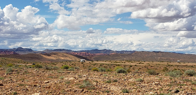
Above is our spot at Snowbird Mesa in Overton, Nevada; just a few miles up the road from Valley of Fire State Park(which is closed for Covid19).
We were here for 32 days. As many of you fully realize, the parameters of the Covid19 shutdowns kept changing almost daily. It became suggested and expected that customers would wear masks in the stores, so Jan and I looked up how to fold a mask. Jan's was from a dishtowel(note butterflies) and mine (not shown) was from a blue bandana. Being fulltime RVers, we do not have an option(out here on BLM land) of food delivery, UPS,Fedex,etc. So we have to mingle with other people at a dump station, propane station, grocery store, and laundry. Luckily Overton was a small town and had no Covid 19 cases(as far as anyone knew)while we were there.
A bonus of our stay was being ably to catch Prickly Pear blossoms and other plants as well.
These tiny flowers pop up among the rocks. The blossoms are smaller than a dime.
Not sure of the name, but this plant has a sage like color with beautiful blue/purple flowers. Could be a variation of Schott's Dalea or a Lupine.
Look close!!!
The little guy--about 5 to 7 inches long is a Horned Lizard. We would see a number of these every day, but only after they moved. They would blend perfectly with the rocks and seemed to be like chameleons in adjusting their own color.
Southern Desert Horned Lizards
The little guy--about 5 to 7 inches long is a Horned Lizard. We would see a number of these every day, but only after they moved. They would blend perfectly with the rocks and seemed to be like chameleons in adjusting their own color.
Southern Desert Horned Lizards
The plant above we thought was definitely an alien from outer space or a 1960's sci-fi movie. But it is a Desert Trumpet.
Very strange!
Very strange!
This picture is taken from our longer walk over on Poverty Flats Mesa. You can see that Lady Blue is being very conscientious about Social Distancing.
It was a beautiful clear evening for the Supermoon on April 7th.
With the RVs at the bottom of the picture, you have an idea how large it seemed in Nevada.
With the RVs at the bottom of the picture, you have an idea how large it seemed in Nevada.
32 days on Snowbird Mesa. The first few weeks were quite pleasant with cool evenings and days in the 70's or low 80's and about 7 to 12 per cent humidity. Some heavy showers would pop up and some very,very strong winds(50 to 60mph) But then around April 20th, it started to get much warmer. By April 24th, we were looking at temps close to 100 degrees and staying fairly warm at night. When we saw a forecast for April 29th of 103 to 105 degrees, we decided it was time to try to find another place. Remember that we are boondocking on the mesa--no electricity, sewer, or water. We had a great 4000 watt generator on board, but you do not want to run it all day and night. So we checked and saw a possibility of BLM land northwest of Cedar City, Utah at the Parowan Gap Petroglyphs. The elevation at Snowbird Mesa in Overton was around 1200 feet and the elevation at the Petroglyphs is 5500 feet. The difference in the temperature forecast is a comfy mid 80's for April 29 versus 103 degrees for Overton. We decided to try it. We head north out of Overton on Route 169 and then north on Interstate 15. It does not take long to begin a climb(in a small northwest section of Arizona).
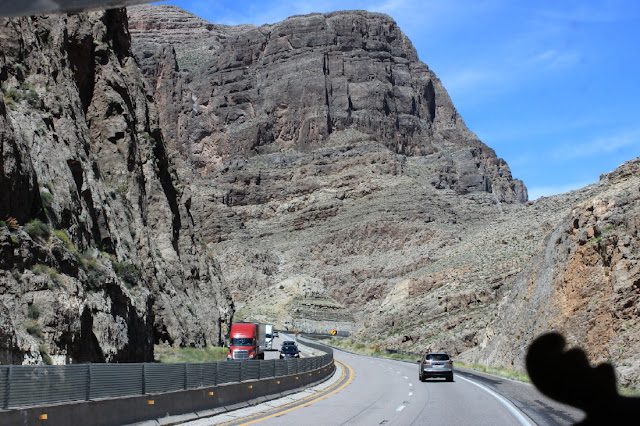
Another scenic highway in the west, cutting through some rugged mountains.
We see that this road follows the Virgin River and the Virgin River Recreation Area. You can see the muddy brown river below.
Virgin River Recreation Area info via Trip Advisor
Note that the above link was through Trip Advisor which gave us a number of beautiful pictures. Try another search if it does not work for you. if you sign up for Trip Advisor you will get emails.
Virgin River Recreation Area info via Trip Advisor
Note that the above link was through Trip Advisor which gave us a number of beautiful pictures. Try another search if it does not work for you. if you sign up for Trip Advisor you will get emails.
Beginning to see some of the red rock associated with Utah.
This part of the highway easily follows the river and valley created over thousands of years ago.
In Utah, we begin to see natural grasslands, Juniper trees and snow covered mountains ranging from 6700 feet to 11,300 feet.
A number of stops have been necessary, including dumping tanks, filling with water and propane, and also some grocery shopping. Eventually we reach Cedar City, happily fill with much less expensive gas($2.12 per gallon) and head out on Route 130 towards the Gap.
Thousands of years and an ancient river cut through the rock here. The river dried up, but the petroglyphs are still here. Pictures coming in the next blog.
Lady Blue is quite happy with her new spot!
The view above us includes a picturesque hiking/atv road, and views of the high snow cover mountains.
Much happier with 70's and 80's weather. The nights drop into the 40's but quickly warm up to the 60's in the morning. When it was 105 degrees in Overton, Nevada, we had mid 80's here and then cooling nicely overnight. Ahead the forecast is low to mid 70's which is fine with us! Still trying to find out what our plan might be for May and June. Alison sent us a link for Maine that indicates strict closures into May and 14 day self quarantine for all of June. The restrictions on private campgrounds are still not clear and state park openings are still not clear. Same still for New Hampshire and Massachusetts and Rhode Island and Connecticut.
Many miles available to hike! And all with beautiful Utah views.


