Translate

Tuesday, September 28, 2021

Summer 2021


Just a few pics and videos from some summer camping.

Starting with some family time at North of Highland Camping Area in North Truro, Massachusetts.

https://www.capecodcamping.com

Mostly a tenting campground. Only a few hookup seasonal sites of the 237 sites.  Lady Blue likes her dry camping spot


Kids love camping at NOH.
Ready for an afternoon of crafts, they discover an inchworm.


Then there happens some collecting of pine cones, sticks , and leaves, and paper flowers to give it a home.

Uncle Sean has only to ask and a volunteer is immediately there to help with camp dishwashing.


Cousin Emilie has the best time.
So hard to get together after summer. More so when there is a good distance between homes-Rhode Island to New Hampshire.


Oh---and besides the fun of the campground there is that short 15 minute walk( or you can drive to a paid parking lot) to one of the best ocean beaches in New England. 

Head of the Meadow Beach


So much fun!
The three sisters and families love getting together.


The time goes by too quickly.
A last event is visiting a familiar restaurant from the past
50 plus years.


Yes, those are local Wellfleet oysters for starters 


An added video from back at our house
on our dirt road.
One lone thistle with a happy bee.


Soon , off on another camping spree.

This time to Maine, beginning with

 Winslow Park and Campground in Freeport, Maine

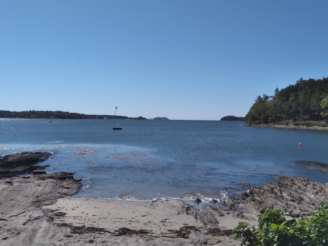
Along part of a walking trail, a view of Harraseeket River and marina.

This park has other wonderful views of Casco Bay.

For this trip we had a very nice wooded campsite. In the past we had been able to have a site on the ocean. This year there are many more campers in September.


We always haver some reason to walk the main street in Freeport. And at least walk into LLBean and look for the huge clock(not working this time??) and maybe some camping, cooking, clothing, and live fish.

After, it is a short few hours drive to Lobster Buoy Campground in South Thomaston. It is towards the end of the finger of land . South of West Penobscot Bay and Southwest of Vinalhaven. Basically, you are looking out at the Atlantic Ocean 

Lobster Buoy on Tripadvisor

With an early reservation, you have a good chance of a water view site for your electric and water hookup. Tenting sites are much easier to reserve with an ocean view


Our site had a partial view this year. 

Next year we will try to reserve earlier.


 A little over a mile from the campground is one of Maine's most liked Lobster Shacks.

McLoons Lobster


The link above is to the website.

You will notice that it is now closed for the season.

A little video to look around the harbor.  On the Maine map you would note that McLoons is on Spruce Head Island. Driving here is a total immersion into the fishing communities of this part of Maine.

Many boats in the harbor, but almost all are working boats.


Like many other restaurants and shacks in Maine, McLoons adapted to Covid with a covered tent for safe seating.


Another discovery(thanks to Mr. Ashcroft) was 

The Maine Oyster Trail

Take time to inspect all of this website. It is divided into geographic sections of the Maine coast. 

We listed a number from the Midcoast tab and from there the Damariscotta River south.

Aphrodite Oysters is only about a football field away from McLoons Lobster, on Spruce head Island. They operate out of their home on the harbor.  As a small business , their main work appears to be in the commercial boats(again quite a few-maybe 30 or so)in this section alone.


Above is their magnet-phone card

Below is the very attractive presentation of our dozen oysters.

They were definitely some of the best we have ever had.


Below is the view from the front of Aphrodite Oyster.

McLoons would be to the left a ways out of sight.


The next move is back south on Route1 to a left on route 127 out of Woolwich(just north of Bath).

We are headed a good distance south towards Georgetown. At the end of one section of the split of this peninsula is Reid State Park looking out at Sheepscot Bay and the end of Sheepscot River.

The other side is where we head first to Sagadahoc Campground looking towards the Kennebec River.

Sagadahoc Bay Campground


This campground has a number of sites with views of the ocean.

We decided that we would instead take a very private campsite up in the woods. We had many opportunities to view the ocean while here.


Above is one of the tenting sites(not accessible to RVs) with a view of the ocean.


Above is a view of the beach close to low tide. Sand goes way out to the break in the land. You can walk on the sand easily. Also you can buy a license and rent equipment to dig clams if you wish. Yes- you have to buy a license. Hard to see, but there is a person clamming out there.


We did say beach. Above is the same view , a little after high tide.
Being sandy, it is a very popular beach for swimming.


Oh, did we mention that cooked lobsters are delivered hot, right to your site. We enjoyed it so much, we had lobster both nights we were there


Leaving the campground we drove over(much longer ride than you would think)to Reid State Park. If you were at the beach pictured previously , this park would be to your left, a very short boat ride.

From this video , you may see that this is a very popular beach with sand and a good surf for swimming.


If you are wondering about the picture below.

We ordered these very comfortable swivel chairs from Bernie and Phyls way back in February.  Then ---with Covid--we kept getting notices that the 6 to 8 weeks took until the end of September to finally receive them.  With the delay, we will gratefully acknowledge that the delivery was free.


Updated


Saturday, January 9, 2021

Utah, Colorado River, Estes Park, Colorado, Nebraska


It has been more than 6 months since our last posting. Some of you may wonder where we have been and where are we now.
The last part first. We are now in Maine, on the coast. Living in our first winter in 15 years. Lady Blue is comfortably resting further north , winterized in mid November and eagerly awaiting reawakening sometime in April. Sadly, we will not be seeing our friends in Quartzsite this year. Next year? Who knows.
The picture above is heading east on Route 70 in Utah, mile marker 104, Salt Wash View. 


Above is the view further along , heading down onto the plain.


The highway is cut through the rock. A little idea from the semi in front of us. Lady Blue has good brakes.


Before too long we are crossing the line into Colorado.


Further along, we come across Dillon Reservoir. We are so not in Utah anymore.  There are some wonderful National Forest Campgrounds here, but it only was early June and the campgrounds were closed.  Also we are well into Covid 19 restrictions.


Another view from Dillon


Following along the Clear Creek and Eagle River  through super green hills.


Early June is very quiet at Vail.  Still some snow on the slopes


Passing the town of Vail and the slopes


Close by also is Copper Mountain Ski Area


No sign of activity though.


Route 7 is also know as Peak to Peak Scenic Byway heading north to Estes Park.


There are wonderful stops along the Peak to Peak. From this view coming into Estes Park, there are view of Mount Meeker and this one we believe is Longs Peak 14,255 feet.


In Estes Park we stay at the KOA with beautiful mountain views.
Due to Covid 19, the access to Rocky Mountain Park was limited. Visitor Centers were closed and tours were only by appointment.


Heading southeast from Estes Park, following the river and Route 34 and the Big Thompson River.


The river is down there between the cabin and the highway.


Route 34 is a narrow windy, but scenic road towards Loveland.


Marsha and Mark , a narrow highway with some serious elevation. Yet, the bicyclists push on.


We had stopped again in Brush, Colorado. There is a wonderful city park there that used to be free for the first night.  Unfortunately , not so any more, but still very reasonable at $25 per night. Last year the second night was $10.  Quite a change with the huge drop in elevation from Estes Park in Colorado to this campground in Nebraska next to a huge cornfield.  We held onto our seats as the winds ranged up to 70 miles an hour over night.

A note to our friends.  We had hit the Covid restrictions starting out of Nevada and then severely restricting our moves in Utah. In the previous blogs you note we spent months on the mesas in Utah. Beautiful , but not the trip to the Grand Tetons we had planned. That being said, we were happy to stay healthy as the pandemic pushed on. Rving was one of the safest ways to move. 
We headed east into Ohio and then into Pennsylvania to one of our favorite campgrounds , Ives Run COE . While there, Jan came down with a stomach flu that lasted one day. The next day she was feeling much better, but was short of breath on our walks and her appetite was unusually small.  
We did not think too much about it as we headed into New York and then Maine to our favorite private campground.  Since Jan still was short of breath and low on appetite we made an appointment at our health care spot.  
When they heard Jan's problem, they sent us on to one of their bigger clinics in Portland, Maine where they could test better. Of course, at this time they first tested for Covid and there was no sign of Covid. A check on the stethoscope and the nurse decided an EKG was a good plan because she was hearing a little afib and increased heart rate.  She consulted with an onsite doctor and they both insisted we head to Maine Medical Hospital in Portland.  
This was interesting because we were still using Lady Blue and this was downtown Portland. But the access from the highway to the emergency room was very easy and clear. 
Of course, the hospital was observing strict Covid procedures which meant that I was not allowed to be with her while they checked. The doctors quickly checked and listened and after a while determined a catscan was necessary.  The catscan revealed what they called an Aortic Dissection. Basically, a tear in the aorta that allowed blood to escape , the heart rate to go up.
The doctors consulted with Jan and then called me to indicate that an
 immediate operation was necessary , or an extreme risk of stroke, heart attack, and death.  That really grabbed our attention! 
The doctor indicated that he had his whole team there and they were operating on someone else at the moment, but they would schedule Jan in for an immediate open heart surgery to repair the tear.
And so they did. The doctors were great. The Covid restrictions were tough, but I did get to see Jan after the surgery at 7am the next morning. Also , a big help was the staff who were great. I had parked Lady Blue in the large hospital lot overnight.
Bottom line.
Jan is doing great! We chilled a bit for the summer, but Jan made a very quick recovery, walking 2 to 4 miles by the end of summer.
We decided to stay in Maine because of Covid. A number of the states we would have to pass through were doing a very poor job of handling the pandemic. Maine was and is doing a very good job, even though the numbers are up.
Also, as an added note, we are building a house in Maine that will put us closer to our kids and grandkids. Much better once Covid eases .  We hope all of you are well and share our hellos with everyone at Quartzsite. We are already missing all of you.


Friday, May 15, 2020

Parowan Gap Petroglyphs,BLM Land, Cedar City, Utah

This Monday will mark 3 weeks here at BLM Land above the Parowan Gap near Cedar City, Utah.  A number of people have visited here to look at the Petroglyphs.  You can almost read their minds, trying to place themselves almost 2,000 years ago.

The signage is great here, explaining the geography and Native American history.  200 million years ago the bedrock lifted up through the wind swept sand dunes that covered much of Utah. An ancient river flowed across the land. As the bedrock layers lifted, the river cut through them. Changing climate dried the river and the Gap became a Wind Gap.
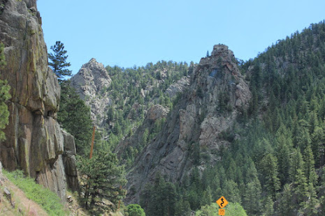
Looking back from the north side , snow covered mountains, app. 10,000 feet or so.


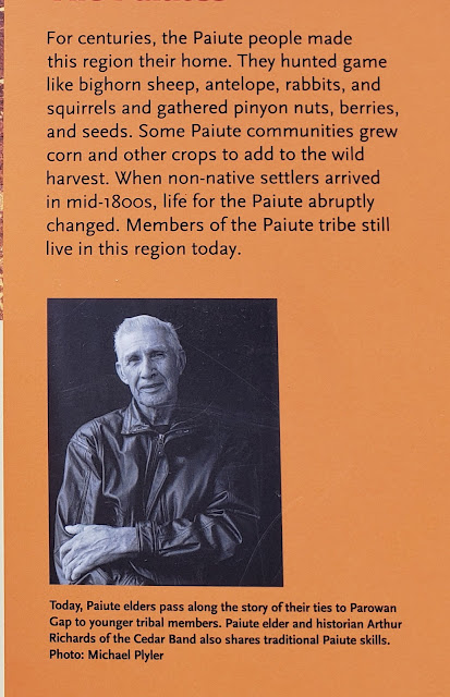
Indian tribes lived here for the past 12,000 years. However, the petroglyphs were created by the Paiutes around 500A.D. Interestingly , the symbols used were mostly universal to all Indian tribes throughout America.


Click Pictures to Enlarge
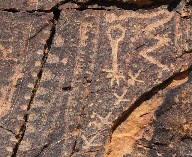
Above: Remember that the icon language was known to most tribes. The upside down bulb represents the leader , who is dead. The gray line represents the travel to this area( a crack in the rock) Other petroglyphs show the sun, the fields, rain and lack of rain, the seasons, and more.  Also, there are different interpretations , even by the experts.

For example: showing the Equinox, and multiple solstice. Showing the valley, narrows , and cairns ;rather than the head and neck.


One interpretation is three figures(upper left), another that they are the three moons of winter.


Before the water dried up for farming, note the abundance of wildlife. Including bighorn sheep, antelope, rabbits, and squirrels. Also , besides harvesting wild crops, they grew corn and other crops.


Some of the circular coils represented various tribes. This is sacred ground for the Paiute and Hopi.


The above crosses might represent birds in flight or tracks. The signs indicate that 
golden eagles, peregrine and prairie falcons, red tailed hawk, and great horned owls live here. We did see a large hawk on one of our hikes.


Seemingly tentatively balanced boulders at the Gap.

Jan on one of the dirt roads leading from the Gap.


Bruce on one of our hikes above the Gap.


Short video from a hike above our camping spot.


A different video from above our area.

Our version of Full Time Rver Social Distancing.


And while relaxing in Lady Blue, a family passes by on a horse ride. Looks like Dad and young son in front. Giving an extra horse some exercise on a lead, And perhaps a daughter on her own horse.