Translate

Saturday, November 10, 2018

Big Stone Gap, Virginia; Cumberland Gap National Park, Virginia, Kentucky, and Tennessee,;Cumberland Falls State Park, Kentucky; Kendall Corps of Engineer Park on Lake Cumberland, Kentucky


From Claytor Lake we head south on Route 81 and a 
nice overnight stop at Hungry Mother State Park. We have
 stayed here before and it is always a pleasant stay with a
 nice hiking trail past the lake.
The next day we opt for a challenging Route 58
 out of Abingdon, Virginia through the Appalachian 
Mountains to Big Stone Gap in the Jefferson National 
Forest. Great views, even on a murky day. In the middle
 of the picture above, you can see a person at the view point 
which is only accessible from the northern side of the 
divided highway. The smudges are from a dirty windshield!
A reminder that you can click on the pictures and videos to enlarge.

Close to the center of town is the  Jessie Lea RV  Park. Alongside a small river with a walking path, it is a very pleasant ,friendly park.
The owner set up most of the park himself. This fall decorated cart is one example.  He is also into antiques, old motorcycles(like 1920's and 30's, and more.


It may be late fall , but the roses are still going.
Along the Riverwalk , by the campground, this live tree carving was done by the campground owner.
We are still heading south on Route 58 .
If you note the 4 lane highway at the bottom, you have some idea of the rolling hills and mountains in the area.

We commented a number of times that almost every property is built on a hillside.  These houses were on fairly level land.


Southwestern Virginia, in farm and mountain country, yet here and there houses like this one.  Impressive.
Colors were still coming in for the lower elevations. 

Jan and I are still amazed at the roads in this section of Virginia and also into Kentucky.  4 lane divided highways with little to almost no traffic in places. Look above and weep New Englanders!

We are now approaching the Cumberland Gap area.
The bison were once plentiful here , even if less so than the plains areas.

Wilderness Road is the National Historical Park Campground that we very much enjoyed.
Having come from the Shenandoah Blue Ridge Mountain area, through the western Virginia valley and then here to the Appalachian Mountains and the Gap, we can appreciate the views of the European settlers. They first stayed east of the Blue Ridge until land became scarce. A while longer to settle the valley beyond.
Then Daniel Boone blazed a trail through the gap in 1769. Then in 1775 Boone and others blazed a road through the gap opening the Kentucky wilderness and more to settlers.


One of the campground loops offers some great foliage color.
Lady Blue is happy in her dry camping spot.
Senior Pass made it $10 per night.
A number of trails are in the area. Also the Visitor's Center had some wonderful movies about the gap and Daniel Boone. The gap pictured in the photo of a painting above was quite different than the extremely difficult pass through the Rockies that Lewis and Clark found in 1803.  This gap, the only one that was found in the 1700's, was already a bison track to the salt licks beyond. It was also an Indian track for many tribes from the south and north to the bountiful hunting ranges. From 1780 to 1810 200,000 to 300,000 people passed through the gap heading west.

The museum covers a number of topics about the trade routes, the explorers, Daniel Boone, and the conflicts between the Native Americans and the settlers, and also between the Native American tribes.  Some mention is also made of the Civil War troops that occupied the land  ; both North and South.  One thing we noticed from paintings , was how the discovery of coal and other minerals encouraged the stripping of the forests.  The mountains in the area became treeless, stark , and uninviting.

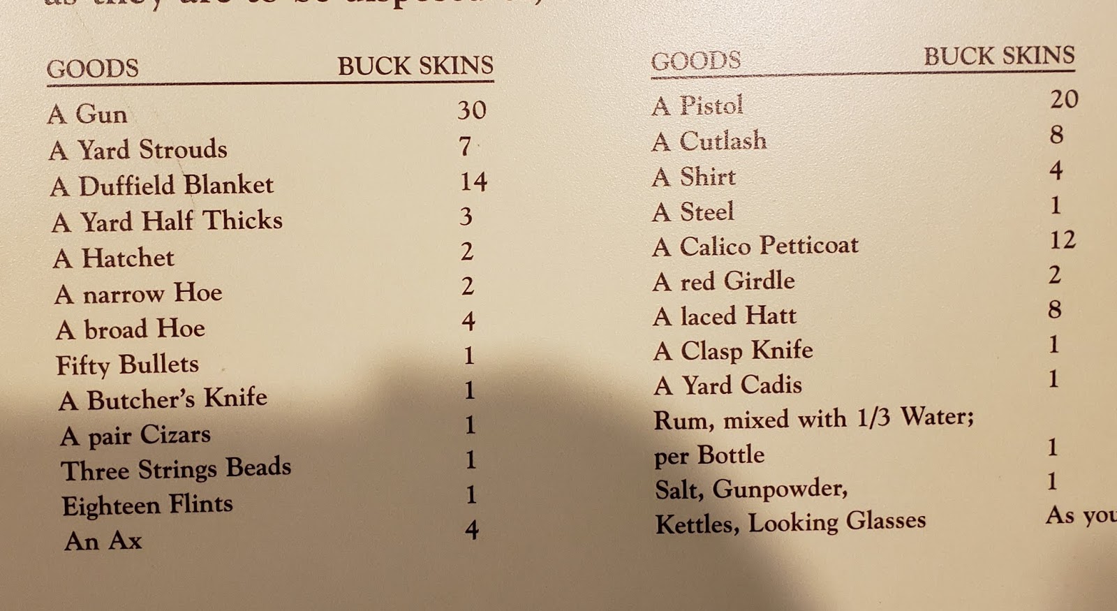
From 1716, this is a chart of the trading prices for European goods. We could understand the 30 buckskin price for a good rifle, but found the market for a calico petticoat at 12 buckskins a little surprising.  

The Wilderness Road and Cumberland Gap are at the intersection of Southwest Virginia, Tennessee, and Kentucky. Even in many small towns there are buildings saved or recreated in the frontier log cabin style  Images for typical Daniel Boone style log cabins . Also enjoy seeing the Kentucky style split rail fences.
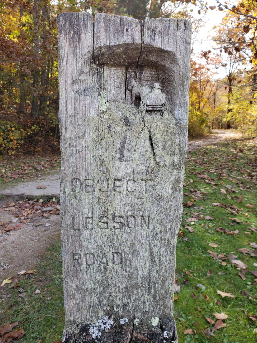
We did a hike from the Visitor's Center road up to the gap on the Wilderness Road Trail.  No real views from there, but a nice hike and trail markers like this one for Object Lesson Road.  Early engineers made a road on this section on the trail to demonstrate 1800's road construction that could last and avoid erosion.

Other markers like this one on the boulder seen below.


Sometimes it is nice to stop on a trail and know that you are standing in a spot occupied by so many from previous years.
Easier to imagine some of what they were seeing and thinking at that time.  As hard as it can be in a modern, busy city, you can even do this following the Freedom Trail in  Boston .
Website for Boston Freedom Trail

From the Cumberland Gap, we follow route 25E up to Corbin and south on 25W to Cumberland Falls State park on the Cumberland River.

Smile Jan and Bruce!
These falls are the largest falls east of the Mississippi and south of Niagara Falls.


Once you click on the arrow button to play the video, most computers will allow you to click in the lower right square to enlarge the video to full screen.


Cumberland Falls State park was on Route 90 and so we continue west on Route 90 which follows the Cumberland River. Sharp curves and some steep sections. Once we begin to head north with Route 27 the land begins to level out to the wonderful Kentucky farm land.  Soon we are coming in towards Lake Cumberland.

Here we stay at one of our favorites, Kendall COE Campground.
Right next door is the Wolf Creek National Fish Hatchery. Inside are long , long concrete fish tanks filled with fingerling trout.

The water constantly moves and thousands of tiny fish are all over the place.


Outside are more concrete fish tanks covered above by netting--to foil predator birds from easy meals.  These fish are much larger to almost fully grown when they are sucked into large trucks to bring to ponds and lakes and rivers in Kentucky and released. It seems that most fish here are Rainbow Trout.

Tuesday, October 30, 2018

Heading West: Ives Run COE, Pa; Bald Eagle State Park, Pa; Shawnee State Park , Pa; Big Meadows Campground, Shenandoah National Park, Va, Claytor Lake, Virginia


Where did the summer go?
As we leave Walnut Grove in Alfred, Maine, the leaves are already changing.  A lot of mileage and no usable data connections for the blog, so this issue will cover a bit of time.

After the Maine Marathon, watching for Sean, we catch a night at White Lake State Park in Tamworth , New Hampshire.

Sean and Bailey took us to Hobbs Tavern and Brewing. A great meal at a very comfortable restaurant.  Website for Hobbs Tavern

Between appointments in Scarborough, Maine, Jan and I pick up a few lobster rolls at Bayley's Lobster Pound Website for Bayley's 
We also drive by what used to be a favorite spot for Jan's folks, Lighthouse Suites. Back then it was called the Lighthouse Motel.


A beautiful spot on Pine Point. Fond memories for Jan and her sisters.

This is early October, but some leaves are beginning to change.

Time to leave New England. Some great moments still fresh like this moment with Madison, Emilie, and Lucas at North of Highland.

We try not to leave New England without at least some New England apples.  This visit was with Scott, Rachel, Lucas, and Lilly at Brookdale Fruit Farm in Hollis, New Hampshire. Brookdale website  We can never find Cortland apples once we leave new England. They make the best apple pies--made by Jan , of course!!!!!!

A nice hug from Lilly

Even wanting to hold a Grandpa hand.

We found a new to us campground in western Mass. This was at Sunsetview Farm Camping Area in Monson.   Leaves were definitely changing here. Website for Sunset View


From Monson, we head our usual way to New York  state on the Mass. Turnpike,and south on Route 88 to Route 86 and then south on Route 15 to Tioga and Ives Run Corps of Engineer Campground. This is our favorite site--we actually reserve this one--in the dry camping section for $10 per night for seniors with the America the Beautiful card.


Woolly Bear caterpillar. Not as many this year.
Already cold weather here, but still time in between rain showers for a good 4 mile walk from our site in the dry camping section to the other site loops in the main section(electric and water) , and full hookup sites.

Jan's favorite site in one of the water and electric sections. We may be tempted to reserve this one next time.
Color changes are a little slower here, but certainly beginning to show.

Not a lot of campers in this section in the fall. Most campers want electric and water in the colder weather.  That's OK with us.

We then head down Pennsylvania US Route 220.  Jan takes some pictures of the many beautiful views on the way.

Farm country, but more open than New England views.

Another new stop for us Bald Eagle Lake State Park 

This state park was close to Route 30 outside Bedford, Pennsylvania. A good resting spot before heading into western Virginia or West Virginia
Heading up to Shenandoah National Park and Big Meadows Campground. Basically , it was Route 30 east to Breezewood, then south on Route 70 into Maryland and a short few miles in West Virginia to Route 522. That takes us to  Winchester, Virginia and Route 37 to Route 81 south to Route 66 east to Front Royal. In Front Royal we head down Route 340 to Luray and Route 211 up to Skyland Drive. The pictures above are from following our GPS on a shortcut, which took us on a one lane road through farms to 211.  Not recommended for RVs but some beautiful landscape.

As a one lane road there was not much traffic, but any traffic created some squeeze plays. The Skyline Drive runs along the ridge in the background.

So happy this time to have some great weather. Much less smog. Visibility great!

This was our first site at Big Meadows Campground.  A little worrisome when we arrived, because the signs on the Skyline Drive indicated this was full.  But we had this site for one night and then we were able to take a non-reservable site for as long as we wanted, up to two weeks.
The Appalachian Trail runs by Lady Blue, about 15 yards to the right.


A little video from our walk up and over to Black Rock above the Lodge.  Black Rock is at 3700 feet elevation. A reminder that the videos should be able to be enlarged.


The Lodge is still very comfortable with a nice fire in the big fireplace.


The view from the Lodge balcony. No, not those strange people , but beyond into the valley.
Our second site offered this view from inside Lady Blue. A little help from our telephoto lens, but still this view and wider.


One of the most popular hikes in Shenandoah NP is Dark Hollow Falls.  The elevation drop is 440 feet and the round trip (from the yellow Skyline Drive) is about 1.5 miles. 


A little video from the bottom of the falls.  This was s busy weekend and there were a number of hikers everywhere!

After 4 nights at Big Meadows, we head south on the Skyline Drive to Elkton, Route 33 and over to Route 81 south again. Back to one of our favorites, Claytor Lake State Park in Dublin, Virginia
A view from the Claytor Lake Trail at the "view" spot below.

The hike above started at the campground at the top of the loop. 
The picture above is from the view point on the left . The circles at the bottom are the rental cabins. This loop that starts in the woods and ends all along the lake is about 4 miles long.


A little video from the gazebo. The dam is to the left here and you can see the marina to the right. The beach is beyond the marina, The cabins are beyond the beach a ways. And the viewpoint picture from before is quite a ways beyond the cabins.

A sailboat out from the beach section

The Shady Ridge Trail is much shorter and is mostly the upper section of this loop. 
The maples are taking on some great color at the end of our stay.